Hamilton Park Historic District (Columbus, Ohio)
Appearance
Hamilton Park Historic District | |
 Contributing buildings | |
 Interactive map highlighting the district among other historic sites and districts | |
| Location | Columbus, Ohio |
|---|---|
| Coordinates | 39°57′57″N 82°58′53″W / 39.96588°N 82.98146°W |
| NRHP reference No. | 83001968[1] |
| CRHP No. | CR-42 |
| Significant dates | |
| Added to NRHP | July 28, 1983 |
| Designated CRHP | January 29, 1987 |
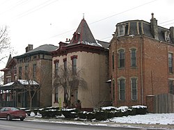
The Hamilton Park Historic District is a historic district in the Near East Side of Columbus, Ohio. The site was listed on the National Register of Historic Places in 1983 and the Columbus Register of Historic Properties in 1987. It is one of few remaining examples of an 1880-1930 upper middle class neighborhood in Columbus. The district also contains an unusual street layout, with three parallel streets creating two islands. It is thought to have been one larger island originally, as can be seen on Jefferson Avenue.[1][2]
See also
[edit]References
[edit]- ^ a b "National Register Information System". National Register of Historic Places. National Park Service. March 13, 2009.
- ^ "National Register of Historic Places Registration Form". National Park Service. Retrieved June 25, 2020.
External links
[edit] Media related to Hamilton Park Historic District (Columbus, Ohio) at Wikimedia Commons
Categories:
- National Register of Historic Places in Columbus, Ohio
- Historic districts on the National Register of Historic Places in Ohio
- 1983 establishments in Ohio
- Columbus Register properties
- Historic districts in Columbus, Ohio
- King-Lincoln Bronzeville
- Columbus metropolitan area, Ohio Registered Historic Place stubs
- Columbus, Ohio stubs


